Create a Shared Model for Infrastructure Execution
The Spatial DNA Unified Model (SUM) provides cities, utilities, and infrastructure organizations with a shared structure for work, assets, locations, costs, status, and decisions, enabling workflows to operate consistently across systems.
Start with one workflow where systems describe the same work differently.
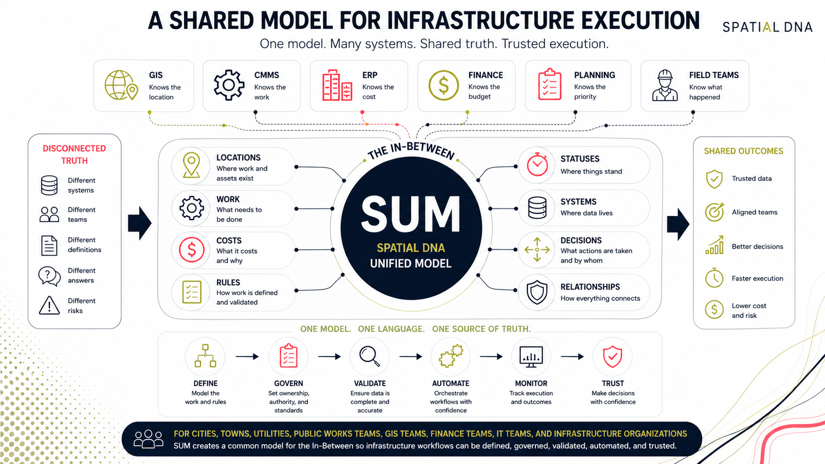
Every system has its own version of the truth.
Most local governments and utilities already rely on GIS, work management, ERP, asset management, and reporting systems, with spreadsheets, APIs, and department-level tools filling the gaps. Each system may work well on its own, but when work moves across them, the organization needs a shared model to keep operational context consistent.
Common symptoms
- Assets, work orders, costs, and locations do not align across systems
- Different departments use different terms for the same operational reality
- GIS, ERP, CMMS, finance, planning, and reporting each hold a partial truth
- Data mapping depends on individual knowledge instead of shared rules - Reports require explanation because the source data is not consistently modeled
- Integrations move data, but the relationships between records remain unclear
- System-of-record ownership is debated after problems appear
The systems may hold data, but the organization still lacks a shared model for execution.
When the model is unclear, every handoff becomes negotiable.
Infrastructure work depends on relationships between requests, locations, assets, work, costs, plans, and outcomes. When those relationships are defined differently across public works, GIS, finance, IT, and planning, mistrust and manual reconciliation follow. Spatial DNA creates a shared operating model that gives systems consistent meaning, ownership, and context before automation, reporting, and AI depend on the data.
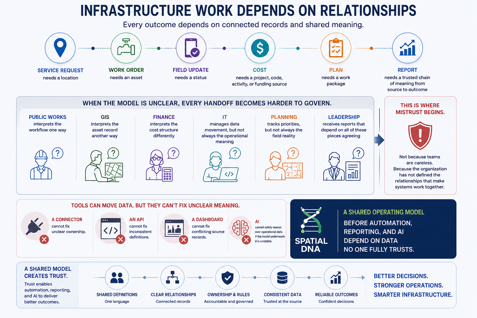
SUM creates a shared structure for systems, workflows, and decisions.
The Spatial DNA Unified Model (SUM) defines how assets, locations, work, costs, plans, projects, requests, and system ownership relate across infrastructure systems. More than a data dictionary, it establishes the shared definitions, relationships, rules, and validation that keep workflows consistent across systems.
The Spatial DNA Unified Model helps teams align:
Assets, locations, work, cost, status, plans, requests, and outcomes
GIS, ERP, CMMS, finance, asset, planning, and reporting data
Systems of record and systems of engagement
Data ownership, authority, and validation rules
Operational workflows and reporting logic
Integration patterns between systems
AI-ready data relationships and workflow context
Reusable models for infrastructure workflow automation
Give systems a shared operational language before automation makes them move fast
Best-fit teams
GIS and Asset Teams
When assets, locations, spatial context, work history, and infrastructure records need to align across systems.
Public Works
When service requests, work orders, field activity, crews, costs, and reporting need to describe the same operational reality.
Utilities
When assets, maintenance, inspections, field work, customer requests, and finance need a clearer shared structure.
IT and Systems Teams
When integrations, APIs, mappings, and data flows need a more consistent model behind them.
Finance and Budget Teams
When operational work needs to become accurate cost, project, labour, material, and reporting data.
Planning and Leadership Teams
When plans, priorities, budgets, execution, and reports need to tell one trusted story.
What Spatial DNA Unified Model makes clearer.
Asset relationships
Define how assets, locations, systems, work history, condition data, and operational records relate.
Work relationships
Clarify how service requests, work orders, inspections, field activity, plans, statuses, and outcomes connect.
Cost relationships
Align labour, materials, equipment, inventory, project codes, cost codes, ERP records, and financial reporting.
Location relationships
Connect with spatial context, GIS records, addresses, service areas, assets, field activity, and reporting views.
System authority
Define which system owns which record, which system can update it, and which system downstream teams should trust.
Create alignment between the systems already in place.
Spatial DNA can be positioned around the shared model behind the systems local government, utility, and infrastructure teams already use.
System categories to reference
- GIS
- ERP
- CMMS
- Work order management systems
- Asset management systems
- Public works software
- Finance and budgeting systems
- Planning and capital program systems
- Inventory and procurement systems
- Field mobility tools
- Reporting and analytics platforms
- API and integration platforms
- Aviation and mission-critical data systems
Where SUM fits in the Spatial DNA platform.
The Spatial DNA Unified Model gives structure to the broader platform.
It works with the platform’s supporting concepts and components:
Execution Control Layer
Uses the shared model to govern how work, data, status, cost, assets, locations, and decisions move across systems.
Specifications
Turn the shared model into defined patterns for automation behavior, data flows, connectors, mappings, validation, and execution logic.
AI + APIs
Use the shared model to make API integration and AI-assisted workflows more governed, explainable, and reliable.
Partner Delivery
Use diagnostics, workshops, workflow mapping, and integration planning to help teams define the model in practical operational terms.
Solution Paths
Field to Finance, Service to Work, Plan to Work, and Aviation Data Operations each depend on shared meaning across systems before handoffs can be controlled.
The Execution Control Layer is where platform architecture becomes operational control.
Map. Define. Control.
You do not need to replace every system to create shared operational truth. You need to define how the systems should understand each other.
Map the model
Map the assets, locations, work, costs, statuses, systems, data fields, rules, teams, and decisions involved in the outcome.
What these reveal
Where different systems describe the same operational reality in different way
Define the relationships
Define how records should relate, which system owns which part of the truth, what data is required, and what validation needs to happen.
What this creates
A shared operating model for public works, utilities, GIS, IT, finance, planning, procurement, operations, partners, and leadership.
Control execution
Use the shared model to support workflow automation, validation, APIs, specifications, monitoring, exception logic, and partner delivery.
What this enables
Infrastructure work that moves across systems with clearer meaning, less ambiguity, and more trust.
Built for complex infrastructure data environments.
Spatial DNA works in the places where public-sector operations, geospatial data, enterprise systems, finance, planning, field execution, APIs, and mission-critical data meet.
The Spatial DNA Unified Model is not a generic data model story. It is about helping infrastructure teams create shared meaning in the operational layer where systems, workflows, data, and decisions depend on each other.
This is especially important in local government and utility environments, where the same outcome may involve public works, utilities, IT, GIS, finance, procurement, inventory, operations, planning, partners, and leadership.
Spatial DNA helps teams move from disconnected data definitions to shared operational truth.
From disconnected records to shared meaning.
When the Spatial DNA Unified Model is in place, teams spend less time debating what the data means and more time improving the outcome.
Before
- Systems describe assets, work, cost, and status differently
- Data mappings depend on individual knowledge
- System authority is unclear
- Reports require manual interpretation
- Integrations move records without shared operational meaning
- Automation depends on inconsistent definitions
- Every department maintains its own view of the truth
After
- Assets, work, costs, locations, and statuses are easier to align
- Data relationships are clearer
- System authority is better defined
- Validation rules can be applied earlier
- Reports are easier to explain
- Automation has a stronger foundation
- Teams can work from a more shared model of execution
The systems describe the work more consistently, and the organization can trust what the data means.
Start with one workflow where the data does not line up.
Bring one workflow where systems are connected, but the records still do not tell the same story.
Spatial DNA can help your team map the data relationships, identify where definitions break down, clarify system authority, and create a practical path toward a shared operating model.
Good diagnostic candidates
- GIS asset to work order
- Work order to ERP cost
- Service request to asset record
- Capital plan to work package
- Inspection to asset condition
- Inventory usage to job cost
- Status update to reporting
- Field update to system of record
- Manual mapping to governed model
- API integration to shared data structure
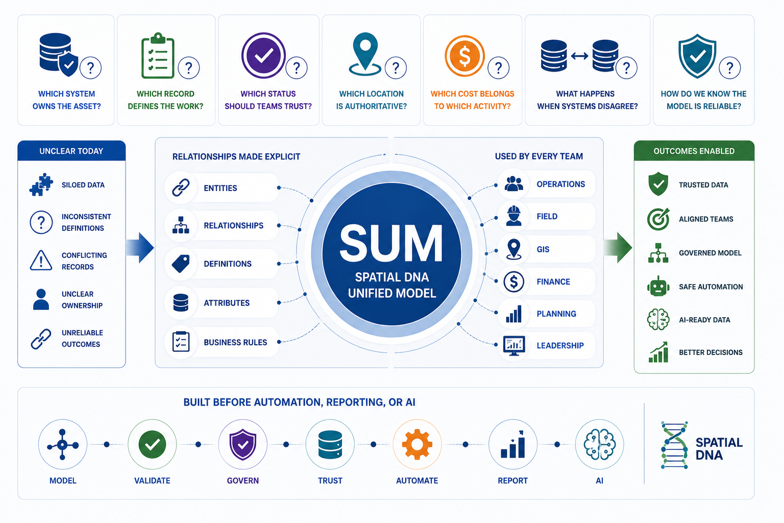
One of the 5 Dysfunctions of Automation: no trusted system of record.
Automation does not fail only because systems are old. It often fails because teams have not agreed what the data means.
Which system owns the asset?
Which record defines the work?
Which status should downstream teams trust?
Which location is authoritative?
Which cost belongs to which activity?
What happens when two systems disagree?
How does the organization know the model underneath the workflow is reliable?
SUM exists to make those relationships explicit before automation, reporting, or AI depends on them.
What is the Spatial DNA Unified Model?
The Spatial DNA Unified Model, or SUM, is a shared operating model that helps infrastructure organizations align assets, work, locations, costs, statuses, systems, rules, and decisions across existing operational systems.
What does SUM help infrastructure teams do?
SUM helps teams clarify data relationships, system authority, ownership, validation rules, and workflow meaning so infrastructure work can move across systems with more trust.
Who is the Spatial DNA Unified Model for?
SUM is for cities, towns, utilities, public works teams, GIS teams, IT teams, finance teams, planning teams, operations leaders, and infrastructure organizations that need existing systems to describe work and outcomes consistently.
Does SUM replace ERP, GIS, CMMS, or asset management software?
No. SUM should be positioned as a shared operating model that helps connect and align existing systems such as ERP, GIS, CMMS, finance, asset management, planning, reporting, and work order management tools.
How is SUM different from an integration?
Integration moves data between systems. SUM helps define what the data means, how records relate, which system is authoritative, and what rules should govern the movement of data between systems.
Why does local government need a unified data model?
Local government teams often depend on many systems across public works, GIS, finance, IT, planning, assets, and operations. A unified model helps reduce confusion, improve data governance, support workflow automation, and make reporting more trustworthy.
How does SUM support AI and APIs?
SUM gives APIs and AI-assisted workflows a clearer data structure to work from. By defining relationships, ownership, validation, and system authority, SUM can help make automation and AI use cases more governed and reliable.
What is the first step?
The first step is to map one workflow where systems describe the same work, asset, location, cost, or status differently. From there, teams can define relationships, identify data gaps, clarify authority, and create a practical path toward shared operational truth.
What is the first step?
The first step is to map one handoff where systems are connected, but the outcome is still hard to trust. From there, teams can define rules, identify validation gaps, and create a path toward governed execution.
Ready to create a shared model for infrastructure execution?
Start with the workflow where your systems describe the same work differently.
Answer a few questions, identify the data model gap, and get a clearer path from disconnected records to trusted execution.orkflow that creates the most confusion, reconciliation, delay, or reporting doubt.